Worldsenders

Some of you won't recognise the picture above, probably taken in the thirties from the eastern corner of Langton Street, looking south south-west across the World's End towards the power station. The road running from left to right is the King's Road. The World's End pub is just off picture to the left; the bus is standing roughly in front of what is now the World's End Pharmacy.
I like to think of the young lady with the long hair, third from the left, walking towards us as Beckett's Celia:
"She had turned out of Edith Grove into Cremorne Road, intending to refresh herself with a smell of the Reach and then return by Lots Road, when chancing to glance to her right she saw, motionless in the mouth of Stadium Street, considering alternately the sky and a sheet of paper, a man. Murphy"
Samuel Beckett, Murphy (1938)

Sunday, April 11, 2010

On our way to Wembley


Yesterday, April 10th 2010, Chelsea beat Aston Villa 3-0 to go through to their seventh FA Cup final in seventeen years. Winners of four of the last thirteen editions, it's strange to think that from their foundation in 1905 until 1994 Chelsea had only reached the final three times, losing in 1915 to Sheffield United and in 1967 to Spurs, before finally winning the FA Cup for the first time in 1970. So, if Chelsea fans might lately have become slightly blasé about winning trophies, this was not the case back in 1970.

Chelsea had beaten Watford 5-1 on 14 March at White Hart Lane to go through to the final against Leeds United, to be played on April 11, exactly 40 years ago today. In the intervening four weeks the World's End turned Chelsea blue. Even though dad was a Fulham supporter, that didn't prevent his 11-year-old son from filling their windows with bright blue posters courtesy of the evening papers. The "parade", or row of shops on the south side of the King's Road between the Community Centre (ex-Chelsea Police Station) and the World's End Pub, joined in too - the local greengrocer's, for example:


As always, Slaidburn Street wouldn't be outdone; its kerb stones were painted blue and white, not at the instigation of the local council, I presume. This photograph, unfortunately in black and white and not blue and white, was published in The Times on match day:


Here's another similar picture that appeared in the press:


Everyone wanted to have their picture taken down Slaidburn Street. Here is yet another snap of a group of skinheads posing in the notorious cul-de-sac:


The above picture is currently available as one of a series of Christmas cards issued by London Books and featuring the messages: 'Merry Christmas from the Chelsea Youth 1970' and 'Happy Christmas from the Chelsea Shed'.


The match was played at Wembley as always. After 90 minutes the score was 2-2 and remained 2-2 after extra time, so a replay was arranged for Wednesday 29 April at Old Trafford. Once again the sides were level at 1-1 at the end of regular time; then Chelsea's David Webb headed home an extra-time winner from an Ian Hutchinson trademark long-throw.


The replay had been an evening kick-off and was watched by a record TV audience of 32 million. At the end what seemed like the entire population of Chelsea came out into the streets to celebrate. The very next day there was a victory parade down the King's Road, ending up at Fulham Town Hall. I was a pupil at Park Walk at the time. Needless to say we were given the morning off school so we wouldn't miss all the fun.

The World's End has always been regarded as the heartland of Chelsea's support, so it comes as no surprise that most of the press photographs of the victory parade were centred on this particular quarter.

Below Ron Harris and Peter Bonetti can be seen holding up the FA Cup at the World's End.


A brief footnote. While checking my facts for the above I noticed that the first ever FA Cup final was won by Wanderers F.C. in 1872. In those days football was a game for gentlemen, and by that I mean public schoolboys and ex-public schoolboys. Wanderers F.C. was in fact a team of Old Harrovians, with important sounding names such as William Kenyon-Slaney and Reginald de Courtenay Welch. Originally formed as Forest Football Club in 1859 and playing in Epping Forest, they became Wanderers F.C. in 1864 after "wandering" to West London where they were to play at both Battersea Park and Lillie Bridge.

Having beaten Royal Engineers 1-0 to win the cup in 1872, Wanderers were given a bye through to the following year's final, as were the rules in those days, to play against Oxford University, who had qualified though the knockout stages. They were also allowed to choose the venue and the match was played on 29 March 1873 at Lillie Bridge Grounds, which was situated just south of West Brompton Station and only about 300 yards north of where Stamford Bridge would be built in 1876.

Wanderers won the cup for the second year running, beating Oxford University 2-0. The attendance of 3,000 was considered low and attributed to the Boat Race occurring later that day, so few turned up or stayed for the whole duration of the game.

Of course this was not the only time the FA Cup final would take place in the West Brompton area. From 1920 to 1922, the final was played at Stamford Bridge itself, before moving to its new home of Wembley in 1923.

Friday, March 19, 2010

King's Road, Chelsea, 1940 - Faith Sheppard


This view of the north side of King's Road from the corner of Park Walk almost as far as Beaufort Street is dated 1940 and is the work of Faith Sheppard (1920). Painted when the artist was just 20, probably while she was studying at the Chelsea School of Art, it appears to be her only painting of Chelsea: most of her other canvasses depict France and in particular Provence.

The kerbs on the S-bend have been painted black and white; this was done in 1939 in preparation for the black-out.


The bend was partially straightened out around 1970 when most of the houses and shops on the southern corner of the bend, opposite the ones shown in the painting, were demolished to make way for Moravian Tower.

On the left of the picture at 392 King's Road we can see the Man in the Moon, once a very fine pub, which for 20 years until 2002 was also home to a theatre. With the arrival of the new millennium the Man in the Moon went the way of too many other Chelsea pubs and became a restaurant. Trading under the name of Eight Over Eight and selling pan-Asian fare, it has been closed for refurbishment since October 2009 following a serious fire which broke out in the kitchen while about 50 people were in the dining area.


Next door at 390 is the Maypole Dairy, which I know not only because the word "Maypole" is written above the shop but also because I consulted the 1934 Post Office Directory for London. For this particular stretch of the King's Road, moving from east to west, i.e. from right to left on the painting, and starting from the archway through to Chelsea Park Dwellings in the middle of the strangely ecclesiastical-looking block, the directory gives the following:

...here are Chelsea Park dwellings...
380 Ashford & Sons, newsagts
382 Davies Wm. dairy
384 Rosenthal Saml. draper
386 Wyatt Wm. Hy butcher
388 Mac Fisheries Ltd. fishmongrs
390 Maypole Dairy Co. ltd
392 Man-in-the-Moon, Harry Wasley
......here is Park walk......

The directory is six years older than the painting but it looks as if the shop next to Maypole's is still a Mac Fisheries in 1940, with its distinctive shop sign, or I should say two signs overhanging the pavement. Today the shop is a Starbucks with a very similar sign sticking out ... just one, and green not blue.

The shop to the left of the archway, number 380, looks very much like a newsagent's (you can see the newsboards propped up against the shopfront) and in 1934 that's exactly what it was. It was a newsagent's in 1921 too, belonging to Alfred Frederick Vedy, with a sideline in postcards of Chelsea. It was still a newsagent's in the 1990s and the place where my dad would spend most of his mornings after he retired, chatting to his friend Sami who worked behind the counter and to anyone who came in to buy a paper. This was how he got to know Yasmin and later Simon Le Bon, who were living in Apollo Place just off the embankment at the time.

Further on is a row of one-storey shops set further back from the street. The pavement follows the line of shops as the road widens. This row has recently been rebuilt and now has two-storeys. The work is ongoing.

On the right of the canvas we can see the side wall of the Roebuck, known to be the favourite watering-hole of Malcolm McLaren and the Sex Pistols back in the 70s.

Thursday, March 18, 2010

Jesse Lawrence

Music Videos by VideoCure

The music is One Love recorded in 1977 by Bob Marley and named 'Song of the Millennium' by the BBC in 1999; the video was made by Don Letts in 1984 to accompany the posthumous Bob Marley compilation album Legend, Marley having died in 1981; the boy featured in the video is Jesse Lawrence - more of him later.

British Grammy-award winning film director and disc jockey, Don Letts, who can be seen on the video grooving with Paul McCartney at 1:36 and shaking hands with a police officer at 2:14, had been a friend of Marley's ever since 1976 when he famously sneaked into Bob's hotel following a gig at the Hammersmith Odeon and spent the night chatting to him.

Don Letts is also credited with having brought together the two musical styles of punk and reggae, resulting in, for example, the Clash recording Junior Murvin's Police and Thieves on their debut album The Clash in 1977 (though Murvin's first comment on hearing it was "They have destroyed Jah work!"), and in Marley's own Punky Reggae Party.

In the mid-70s Letts ran the King's Road clothes store Acme Attractions in the basement of Antiquarius, selling "electric-blue zoot suits and jukeboxes, and pumping dub reggae all day long". The store attracted the likes of The Clash and the Sex Pistols, Chrissie Hynde, Patti Smith, Debbie Harry and Marley himself, and is often cited as the "cradle of punk". Letts subsequently became resident DJ at the Roxy. By early 1977 not enough punk songs had been recorded to provide an evening's entertainment, so Don filled the gaps with selections from his dub and reggae collection. And that is the story behind the punk/reggae connection:

"The Wailers will be there, The Damned, The Jam, The Clash – Maytals will be there, Dr. Feelgood too." (Punky Reggae Party, Bob Marley & the Wailers)

When the One Love video came out, a lot of people automatically assumed the boy seen walking down the King's Road was one of Bob Marley's sons, but in fact his name is Jesse Lawrence, he's British not Jamaican and he was brought up on the World's End Estate. The opening shot shows one of the Estate's towers: Jessie lived up there on the eighteenth floor. The indoor shots were filmed in his flat. Jesse's parents Bernie and Paul had been part of the punk scene in the 70s and were friends of Don Letts'. Bernie was famed for her culinary skills and had a part-time job cooking for John Lydon (Johnny Rotten) while he lived at 45 Gunter Grove. She was once asked to model for Vivienne Westwood but had to refuse due to her commitments in looking after a young family. As Bernadine Lawrence she went on to write the best-selling How to Feed Your Family for Five Pounds a Day.

Alongside shots of the Estate and Lots Road Power Station, there are also two particular sequences at 1:07 and 1:19 of Jesse looking into someone's window halfway down Slaidburn Street. You can see the lights of what is now Somerfield and the red brick of the World's End Estate in the background.

In the closing sequence, filmed in the piazza at the junction with Royal Avenue, you can see Jesse's little brother Rene, in particular at 2:17. At the front of the crowd behind Jesse are members of the Birmingham pop/reggae band Musical Youth, one of whom is holding Rene. They had a big hit in 1982 with Pass the Dutchie and the video was made by ... Don Letts.

Jesse, who also stars in the "Waiting in Vain" video, went to Park Walk School and is a true Worldsender. He studied painting and photography at the Chelsea School of Art & Design, and wrote and acted in the theatre before becoming turning his hand to film-making and co-founding the production company la famiglia together with secondary school friends and fellow West Londoners Cristian Solimeno and Kaleem Aftab. With la famiglia he wrote and directed, among other things, the UK Film Council backed short Mash Up (2006), including location shots filmed in Ladbroke Grove and on Albert Bridge, and Much Ado About A Minor Ting (2007), funded by the prestigious Cinema Extreme Scheme, and filmed around West London's famous Trellick Tower. More recently he has been collaborating with other production companies.

Special thanks to Jesse for confirming all the details of this story and for adding a few more.

Tuesday, February 9, 2010

My Family in Chelsea

The people of the World's End come from all over the world. My eldest daughter spent a year at Park Walk in the mid-nineties and her class was as cosmopolitan as could be. Alongside three or four all white British and one Caribbean/white boy, were children from, or whose parents had come from, every corner of the globe: Turkey, Algeria, Pakistan, India, Lithuania, the USA, Japan, Abu Dhabi, Algeria, to name but a few. This reflects the ethnic make-up of the World's End today.

When I was at Park Walk in the sixties, things were superficially quite different. Apart from Nigerian Jolomi and Italian Loris, the rest of my classmates were monochrome white. Yet, appearances can deceive. Hardly any of these children's great great great grandparents, let's say, would have lived locally. Before the 1790s the World's End was home to a few farmers and peasants, their livestock and a couple of pubs. Chelsea villagers lived mainly in the streets around the Old Church, most of which were bulldozed to make way for the new Embankment in the 1870s, some of them, such as the photographer James Hedderly, subsequently relocating to the burgeoning World's End. Other Worldsenders may have arrived from newly gentrified parts of East Chelsea but most of them came from the four corners of Britain and Ireland.

A glance at the 1881 census will confirm. Taking five pages at random, numbers 33 to 53 Blantyre Street to be precise, we find that, of the 65 adults listed (obviously most of the children were born locally), only 9 were born in Chelsea; 17 were born in other parts of London, 12 in Devon, 6 in Somerset, 4 in Suffolk, 4 in Ireland, 2 in Sussex and one each in Dorset, Buckinghamshire, Nottinghamshire, Staffordshire, Surrey, Huntingdonshire, Hertfordshire, Berkshire and Worcestershire; plus a German and a Frenchwoman.

"...Give me your tired, your poor,
Your huddled masses yearning to breathe free..."

As far as my own family is concerned, mum was from Shrewsbury and dad was born in Shepherd's Bush but moved to Chelsea before he was ten. His father, paternal grandfather and great grandfather were all born and raised in the Mortlake/Barnes area, but the latter's father was born elsewhere, probably Berkshire, and moved to Mortlake soon after 1800. Dad's parents were still in Mortlake in 1905 but had moved to Fulham/Hammersmith by 1911. Dad was born in 1920 and the family came to the World's End in the late 20s.

Here he is at Fulham Cross, aged about seven.


They were to live in rooms on the ground floor of 446 King's Road, two doors from the Stanley Arms as was, later to be renamed the Magpie and Stump, and now Pucci Pizza, on the corner of Limerston Street. Dad never talked that much about his childhood. He went to Park Walk, then "Chelsea Big Boys" in the Park Walk annexe. I think they were pretty poor; he always used to say how a special treat would be "bread and dripping", like something out of Monty Python's The Four Yorshiremen, and how they used to buy broken biscuits because they were cheaper ("Have you got any broken biscuits?" "No" "Well, give 'em to me and I'll break 'em for you"). On his birth certificate it says his dad was a "hotel porter, ex-army", though I haven't been able to find his military records. My dad once said his father had worked as a potman in the Cremorne Arms. I don't have a picture of him. He always called my dad Abie, though his real name was Les(lie), apparently in honour of a Jew who had "been good to him". I suspected and hoped, that this story might indicate some Jewish ancestry, but having traced my family history back beyond 1800 I have found to my disappointment not one trace of Jewish blood.

He also said his mother was bedridden; he didn't say how long for. The only picture I have of her is this one, sitting in the window of 446 King's Road.


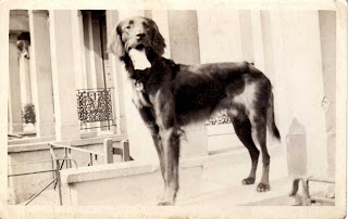
The dog was dad's. Here he is standing guard in the porch of the same house:


And again in the back yard on top of an Anderson shelter, which would suggest the photo was taken sometime in 1940.


Here's dad himself on the same roll of film. Looks like the photo was taken by the dog!


At a certain point the family were bombed out of 446 King's Road. My old schoolfriend Tim Crook has done a lot of research on the Chelsea Blitz and when I told him about this he had a look through his boxes of documents and found a reference to a small high explosive bomb falling at the rear of 448 King's Road on 19th October 1940 with no casualties. Jo Oakman, whose blitz diary is deposited in the local library, also makes a reference to a bomb coming down in the ParkWalk/Limerston Street area on the 19th. This date is borne out by another fact. Dad was deaf in one ear thanks to a burst eardrum. This happened, he said, when a bomb exploded just a few feet away from him. His R.A.F. records show he was in service from 30.8.1940 to 31.8.1940 and then from 8.11.1940 until his release on 10.12.1945. On October 19th 1940 he would have been in Chelsea, so it looks likely that this was the occasion on which his eardrum was burst and his family bombed out. The house at 446 King's Road remained standing, as it does today, but may have been badly damaged.

They appear to have been rehoused in a rather posher part of Chelsea, as the next address I have for them, in 1945 and 1946, is 1 Britten Street, round the corner from St Luke's Church.

Anyway, that's my war story. I know it's not quite as dramatic as Donald Wheal's account of the bombing of the Guinness Trust Buildings in February 1944, but there it is. That's all I have to tell.

My parents met while dad was stationed in Shrewsbury and they married there in November 1946. In August 1947 they are living in a presumably requisitioned flat at the even posher address of 10 Embankment Gardens. Here are the happy couple in front of their home:


Some time before May 1955 they were moved to a one-bedroom council flat at 14 Apollo House on the newly built Cremorne Estate and in 1960, a year after I was born, they were allocated a two-bedroom flat in Riley House, where I was brought up. One good thing about this flat was that it offered a view of (unfortunately not 'into') Stamford Bridge, Battersea and Albert Bridges and Lots Road and Battersea Power Stations.

The photograph below, taken from Riley House, shows Battersea Power Station back in the days when smoke still poured out from its chimneys:


Saturday, February 6, 2010

Names and Contours

Chelsea itself is shaped like a huge horse's head, just like the one a certain fictitious Hollywood film producer found in his bed; and the World's End is its snout, maybe just the lower part of the snout; it really depends on where exactly you consider the World's End to end.


No problem with the southern boundary, which can be nothing but the river. In the west we come to more water, with Chelsea turning into Fulham and the World's End into Sand's End at Chelsea Creek, also known as Counter's Creek, a mainly subterranean stream which rises in Kensal Green and flows through Olympia and West Brompton Stations, in between Brompton Cemetery and Stamford Bridge (the stadium), under Stamford Bridge (the bridge) and Stanley Bridge and into the Thames between Lots Road Power Station and Chelsea Harbour. In 1859-63 much of it was culverted and the West London Line was built along its course. The Creek and the railway part company near the southern corner of Lots Road, running north and south of Chelsea Harbour respectively, the former into the Thames and the latter across Battersea Railway Bridge.

The northern boundary of western Chelsea runs straight down the middle of the Fulham Road, the north side being in Kensington; in fact most people would not consider Fulham Road to be World's End, which is felt to be situated mainly between the King's Road and the river. On the other hand, no one would deny that Slaidburn Street, running north off the King's Road, belonged to the World's End. Basically, the further away from King's Road and the closer to Fulham Road you get, the less likely you are to call it World's End.

A similar concept holds true for the eastward extension. Whereas most people would include the S-bend at Moravian Corner and Milman's Street, others might go as far as Beaufort Street and Battersea Bridge.

I'd always thought the World's End corresponded to the postal district of SW10, until I looked at the street signs and found out that SW10 extended to the north as far as the Old Brompton Road. The name corresponding to SW10 is West Brompton, so the World's End can be said to be the southern half of West Brompton.

The definite article is optional in the name of (the) World's End, as it is in (the) King's Road and (the) Fulham Road. Through a series of Google searches, having cleverly eliminated the millions of references to Pirates of the Caribbean: At World's End along with William Morris's The Well at the World's End, I discovered that the World's End and the King's Road are more often found WITH the article, Fulham Road WITHOUT. On the other hand, the expression "at/in World's End, Chelsea" is much more widespread than "at/in the World's End, Chelsea", which hardly appears at all.

Until 2002 World's End south of the King's Road corresponded to the South Stanley ward, named after Stanley House and Stanley Bridge on the border with Fulham, electing two (Labour) councillors to the Royal Borough of Kensington & Chelsea (before 1965 to the Metropolitan Borough of Chelsea). North Stanley was north of the King's Road. Since 2002 South Stanley has been incorporated into the new Cremorne ward.

Thursday, February 4, 2010

Lost streets, Meek Street and the Proud City


World's End 1894-6

The World's End has lost many street names over time. From east to west these include Ann's Place off Milman's Street (once Milman's Row), Gilray (previously Strewan) Square and Lacland Terrace, all buried beneath the council's Cremorne Estate, completed in 1956, the latter two being commemorated in the blocks Gilray House and Lacland House. Riley Street, which used to run from the embankment in a straight line up to the King's Road and coming out opposite Limerston Street, has survived, albeit bent around Apollo House and the gardens and playground in front of Riley House and truncated so as to end at Ann Lane. Jackson's Buildings and Foundry Place, two cul-de-sacs running north off World's End Passage, had already been swept away by the Chelsea Housing Improvement Society Limited's slum clearance of 1929-31, which erected Follett, Albert Gray, Macnamara and Walter Houses.


Further streets were sacrificed to the World's End Estate, completed in 1977; Luna Street, Seaton Street and Dartrey Road disappeared, along with Raasey, Bifron and Vicat Streets. Rather like Riley Street mentioned above, Blantyre Street remains as a stump.

Of the criss-cross of streets south-west of Cremorne Road, between the King's Road and Lots Road, only one has gone, victim not to any housing scheme, but bombed out of existence during the Second World War, as the Germans sought to hit Lots Road Power Station. Meek Street ran from Lots Road across Tetcott, Upcerne and Uverdale Roads as far as Tadema Road. It still exists according to Google Maps (according to Google Maps the whole of Chelsea is called Kensington), but in effect what remains of it is now considered to be an extension of Uverdale Road, as the street sign says. The rest of Meek Street now lies beneath Westfield Park, laid out over the bomb site.

Below is a photograph of the junction of Meek Street and Upcerne Road taken in 1944 after the bombing.


Walter E. Spradbery, who produced 62 successful posters for the London Underground between 1912 and 1944, clearly based one of his posters on the photograph above. In 1944 he produced a series of six posters under the title The Proud City, depicting iconic London buildings which had survived the Blitz in the midst of devastation all around. Lots Road Power Station (Chelsea Power House in the poster) was honoured along with the Tower of London, the Temple Church and Library, St Thomas's Hospital and the Houses of Parliament, the Church of St Clement Danes and St Paul's Cathedral. Each image is accompanied by a poetic quotation. One time West Chelsea resident James McNeill Whistler provides that for the Power Station:

"... the poor buildings lose themselves in the dim sky, and the tall chimneys become campanili, and the warehouses are palaces in the night, and the whole city hangs in the heavens ..."


At the end of the war a number of prefabs, still standing in the late sixties when my dad took me round to gape at them, were erected on the bomb site. Ex-Chelsea star (though apparently a boyhood Fulham fan) Alan Hudson is known to have been brought up in one of these. A glimpse of them can be had on the left-hand side of this still from the 1952 film I Believe in You, which shows Cecil Parker walking down Upcerne in the direction of the Power Station. Most of the site is now covered by Westfield Park.

Tuesday, February 2, 2010

Francis John Minton (1917-1957)

The World's End public house on King's Road, Chelsea, as painted by John Minton.

Minton lived and died in a studio flat at 9 Apollo Place, a cul-de-sac off the southern end of Riley Street, close to the river, which had also been the home of Francis Bacon and the critic David Sylvester. Minton's suicide was reported in the Daily Mirror of Tuesday 22 January, 1957.


On the 24th the Times, despite getting the address wrong (they call it Apollo Street), beneath the headline "Bouts of alcoholism", adds that: "... police found a diary with the pages for last Monday to Friday ruled through and the word "drunk" written across them ... By his bedside was a book, The Complete Inebriate, dealing with the psychological aspect of inebriation cases."

He left the flat in Apollo Place to Henrietta Moraes, model and muse for Bacon, Lucien Freud and the artists of the Soho subculture. Minton is also remembered for Freud's portrait of him.

John Minton by Lucien Freud

Monday, February 1, 2010

Early references to the World's End


From The Times, June 3, 1816.

George III and his consort Queen Charlotte were frequent visitors to Chelsea Farm the residence of Lady Cremorne in the early part of the 19th century. Chelsea Farm would later come to be known as Cremorne House and its grounds would become the famous Cremorne Gardens. Interestingly the article also refers to the estate as the "World's End", presumably from the name of the nearby tavern.

From The Times, December 18, 1794.

Recently built houses in Riley Street to be sold "By Mr. Pettitt, At the Sign of the World's End, Chelsea, on Tuesday the 23rd inst.* precisely at 2 o'clock"
* abbreviation for "instante mense", meaning a date of the current month, such as "the 5th inst."

Potential buyers would have been well-advised to take up the offer. The air was of a particularly salubrious nature: in 1831, Patrick Gibson of World's End Passage passed away at the age of 111.


Ye Olde World's End


The second World's End pub.

The sign says "Ye Olde World's End". Well, at least they didn't write "Worlde's". In the window is also written "World's End Distillery" (I always thought that particular epithet was an invention of the 1980s).

The gin palace seen above was built in the mid-19th century and replaced by the edifice we see today in 1897. This picture was probably taken in the 1890s. The single-storey structure on the right, which many will remember as the Salvation Army Mission and which survived until the construction of the new World's End Estate and accompanying piazza in the 1970s, at the time housed stables. I can make out:

World's End Stables
Job Master
Dealer in Horses
"Horses for any period"

In the 1910s and 1920s this odd little building was used as a cinema, known locally, according to Alf Goldberg in World's End for Sir Oswald, Portraits of Working-Class Life in Pre-War London, as The Bug 'Ole.

The original World's End Tavern


This was the original incarnation of the World's End Tavern. It's highly likely that this is the hostelry referred to in the following dialogue from William Congreve's Love for Love (1747):

MRS FRAIL Pooh, here's a clutter: why should it reflect upon you? I don't doubt but you have thought yourself happy in a hackney coach before now. If I had gone to Knight's Bridge, or to Chelsea, or to Spring Garden, or Barn Elms with a man alone, something might have been said.
MRS FORESIGHT Why, was I ever in any of those places? What do you mean, sister?
MRS FRAIL Was I? What do you mean?
MRS FORESIGHT You have been at a worse place.
MRS FRAIL I at a worse place, and with a man!
MRS FORESIGHT I suppose you would not go alone to the World's End.
MRS FRAIL The World's End! What, do you mean to banter me?
MRS FORESIGHT Poor innocent! You don't know that there's a place called the World's End? I'll swear you can keep your countenance purely: you'd make an admirable player.
MRS FRAIL I'll swear you have a great deal of confidence, and in my mind too much for the stage.
MRS FORESIGHT Very well, that will appear who has most; you never were at the World's End?
MRS FRAIL No.

The World's End Tavern around 1790.

The 1836 map below, given the shape of the building as drawn above, with a large extension in front on the right-hand side, would appear to suggest that the pub faced west and not directly onto the King's Road, which is not surprising as the latter remained the King's private road until 1830.