Worldsenders

Some of you won't recognise the picture above, probably taken in the thirties from the eastern corner of Langton Street, looking south south-west across the World's End towards the power station. The road running from left to right is the King's Road. The World's End pub is just off picture to the left; the bus is standing roughly in front of what is now the World's End Pharmacy.
I like to think of the young lady with the long hair, third from the left, walking towards us as Beckett's Celia:
"She had turned out of Edith Grove into Cremorne Road, intending to refresh herself with a smell of the Reach and then return by Lots Road, when chancing to glance to her right she saw, motionless in the mouth of Stadium Street, considering alternately the sky and a sheet of paper, a man. Murphy"
Samuel Beckett, Murphy (1938)

Tuesday, February 9, 2010

My Family in Chelsea

The people of the World's End come from all over the world. My eldest daughter spent a year at Park Walk in the mid-nineties and her class was as cosmopolitan as could be. Alongside three or four all white British and one Caribbean/white boy, were children from, or whose parents had come from, every corner of the globe: Turkey, Algeria, Pakistan, India, Lithuania, the USA, Japan, Abu Dhabi, Algeria, to name but a few. This reflects the ethnic make-up of the World's End today.

When I was at Park Walk in the sixties, things were superficially quite different. Apart from Nigerian Jolomi and Italian Loris, the rest of my classmates were monochrome white. Yet, appearances can deceive. Hardly any of these children's great great great grandparents, let's say, would have lived locally. Before the 1790s the World's End was home to a few farmers and peasants, their livestock and a couple of pubs. Chelsea villagers lived mainly in the streets around the Old Church, most of which were bulldozed to make way for the new Embankment in the 1870s, some of them, such as the photographer James Hedderly, subsequently relocating to the burgeoning World's End. Other Worldsenders may have arrived from newly gentrified parts of East Chelsea but most of them came from the four corners of Britain and Ireland.

A glance at the 1881 census will confirm. Taking five pages at random, numbers 33 to 53 Blantyre Street to be precise, we find that, of the 65 adults listed (obviously most of the children were born locally), only 9 were born in Chelsea; 17 were born in other parts of London, 12 in Devon, 6 in Somerset, 4 in Suffolk, 4 in Ireland, 2 in Sussex and one each in Dorset, Buckinghamshire, Nottinghamshire, Staffordshire, Surrey, Huntingdonshire, Hertfordshire, Berkshire and Worcestershire; plus a German and a Frenchwoman.

"...Give me your tired, your poor,
Your huddled masses yearning to breathe free..."

As far as my own family is concerned, mum was from Shrewsbury and dad was born in Shepherd's Bush but moved to Chelsea before he was ten. His father, paternal grandfather and great grandfather were all born and raised in the Mortlake/Barnes area, but the latter's father was born elsewhere, probably Berkshire, and moved to Mortlake soon after 1800. Dad's parents were still in Mortlake in 1905 but had moved to Fulham/Hammersmith by 1911. Dad was born in 1920 and the family came to the World's End in the late 20s.

Here he is at Fulham Cross, aged about seven.


They were to live in rooms on the ground floor of 446 King's Road, two doors from the Stanley Arms as was, later to be renamed the Magpie and Stump, and now Pucci Pizza, on the corner of Limerston Street. Dad never talked that much about his childhood. He went to Park Walk, then "Chelsea Big Boys" in the Park Walk annexe. I think they were pretty poor; he always used to say how a special treat would be "bread and dripping", like something out of Monty Python's The Four Yorshiremen, and how they used to buy broken biscuits because they were cheaper ("Have you got any broken biscuits?" "No" "Well, give 'em to me and I'll break 'em for you"). On his birth certificate it says his dad was a "hotel porter, ex-army", though I haven't been able to find his military records. My dad once said his father had worked as a potman in the Cremorne Arms. I don't have a picture of him. He always called my dad Abie, though his real name was Les(lie), apparently in honour of a Jew who had "been good to him". I suspected and hoped, that this story might indicate some Jewish ancestry, but having traced my family history back beyond 1800 I have found to my disappointment not one trace of Jewish blood.

He also said his mother was bedridden; he didn't say how long for. The only picture I have of her is this one, sitting in the window of 446 King's Road.


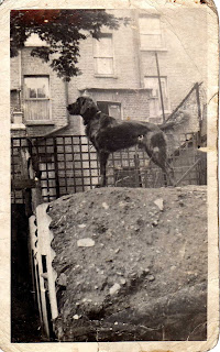
The dog was dad's. Here he is standing guard in the porch of the same house:


And again in the back yard on top of an Anderson shelter, which would suggest the photo was taken sometime in 1940.


Here's dad himself on the same roll of film. Looks like the photo was taken by the dog!


At a certain point the family were bombed out of 446 King's Road. My old schoolfriend Tim Crook has done a lot of research on the Chelsea Blitz and when I told him about this he had a look through his boxes of documents and found a reference to a small high explosive bomb falling at the rear of 448 King's Road on 19th October 1940 with no casualties. Jo Oakman, whose blitz diary is deposited in the local library, also makes a reference to a bomb coming down in the ParkWalk/Limerston Street area on the 19th. This date is borne out by another fact. Dad was deaf in one ear thanks to a burst eardrum. This happened, he said, when a bomb exploded just a few feet away from him. His R.A.F. records show he was in service from 30.8.1940 to 31.8.1940 and then from 8.11.1940 until his release on 10.12.1945. On October 19th 1940 he would have been in Chelsea, so it looks likely that this was the occasion on which his eardrum was burst and his family bombed out. The house at 446 King's Road remained standing, as it does today, but may have been badly damaged.

They appear to have been rehoused in a rather posher part of Chelsea, as the next address I have for them, in 1945 and 1946, is 1 Britten Street, round the corner from St Luke's Church.

Anyway, that's my war story. I know it's not quite as dramatic as Donald Wheal's account of the bombing of the Guinness Trust Buildings in February 1944, but there it is. That's all I have to tell.

My parents met while dad was stationed in Shrewsbury and they married there in November 1946. In August 1947 they are living in a presumably requisitioned flat at the even posher address of 10 Embankment Gardens. Here are the happy couple in front of their home:


Some time before May 1955 they were moved to a one-bedroom council flat at 14 Apollo House on the newly built Cremorne Estate and in 1960, a year after I was born, they were allocated a two-bedroom flat in Riley House, where I was brought up. One good thing about this flat was that it offered a view of (unfortunately not 'into') Stamford Bridge, Battersea and Albert Bridges and Lots Road and Battersea Power Stations.

The photograph below, taken from Riley House, shows Battersea Power Station back in the days when smoke still poured out from its chimneys:


Saturday, February 6, 2010

Names and Contours

Chelsea itself is shaped like a huge horse's head, just like the one a certain fictitious Hollywood film producer found in his bed; and the World's End is its snout, maybe just the lower part of the snout; it really depends on where exactly you consider the World's End to end.


No problem with the southern boundary, which can be nothing but the river. In the west we come to more water, with Chelsea turning into Fulham and the World's End into Sand's End at Chelsea Creek, also known as Counter's Creek, a mainly subterranean stream which rises in Kensal Green and flows through Olympia and West Brompton Stations, in between Brompton Cemetery and Stamford Bridge (the stadium), under Stamford Bridge (the bridge) and Stanley Bridge and into the Thames between Lots Road Power Station and Chelsea Harbour. In 1859-63 much of it was culverted and the West London Line was built along its course. The Creek and the railway part company near the southern corner of Lots Road, running north and south of Chelsea Harbour respectively, the former into the Thames and the latter across Battersea Railway Bridge.

The northern boundary of western Chelsea runs straight down the middle of the Fulham Road, the north side being in Kensington; in fact most people would not consider Fulham Road to be World's End, which is felt to be situated mainly between the King's Road and the river. On the other hand, no one would deny that Slaidburn Street, running north off the King's Road, belonged to the World's End. Basically, the further away from King's Road and the closer to Fulham Road you get, the less likely you are to call it World's End.

A similar concept holds true for the eastward extension. Whereas most people would include the S-bend at Moravian Corner and Milman's Street, others might go as far as Beaufort Street and Battersea Bridge.

I'd always thought the World's End corresponded to the postal district of SW10, until I looked at the street signs and found out that SW10 extended to the north as far as the Old Brompton Road. The name corresponding to SW10 is West Brompton, so the World's End can be said to be the southern half of West Brompton.

The definite article is optional in the name of (the) World's End, as it is in (the) King's Road and (the) Fulham Road. Through a series of Google searches, having cleverly eliminated the millions of references to Pirates of the Caribbean: At World's End along with William Morris's The Well at the World's End, I discovered that the World's End and the King's Road are more often found WITH the article, Fulham Road WITHOUT. On the other hand, the expression "at/in World's End, Chelsea" is much more widespread than "at/in the World's End, Chelsea", which hardly appears at all.

Until 2002 World's End south of the King's Road corresponded to the South Stanley ward, named after Stanley House and Stanley Bridge on the border with Fulham, electing two (Labour) councillors to the Royal Borough of Kensington & Chelsea (before 1965 to the Metropolitan Borough of Chelsea). North Stanley was north of the King's Road. Since 2002 South Stanley has been incorporated into the new Cremorne ward.

Thursday, February 4, 2010

Lost streets, Meek Street and the Proud City


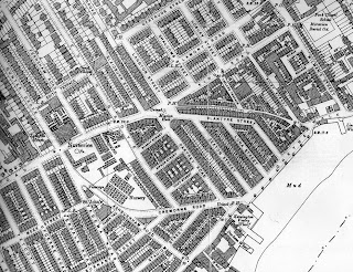
World's End 1894-6

The World's End has lost many street names over time. From east to west these include Ann's Place off Milman's Street (once Milman's Row), Gilray (previously Strewan) Square and Lacland Terrace, all buried beneath the council's Cremorne Estate, completed in 1956, the latter two being commemorated in the blocks Gilray House and Lacland House. Riley Street, which used to run from the embankment in a straight line up to the King's Road and coming out opposite Limerston Street, has survived, albeit bent around Apollo House and the gardens and playground in front of Riley House and truncated so as to end at Ann Lane. Jackson's Buildings and Foundry Place, two cul-de-sacs running north off World's End Passage, had already been swept away by the Chelsea Housing Improvement Society Limited's slum clearance of 1929-31, which erected Follett, Albert Gray, Macnamara and Walter Houses.


Further streets were sacrificed to the World's End Estate, completed in 1977; Luna Street, Seaton Street and Dartrey Road disappeared, along with Raasey, Bifron and Vicat Streets. Rather like Riley Street mentioned above, Blantyre Street remains as a stump.

Of the criss-cross of streets south-west of Cremorne Road, between the King's Road and Lots Road, only one has gone, victim not to any housing scheme, but bombed out of existence during the Second World War, as the Germans sought to hit Lots Road Power Station. Meek Street ran from Lots Road across Tetcott, Upcerne and Uverdale Roads as far as Tadema Road. It still exists according to Google Maps (according to Google Maps the whole of Chelsea is called Kensington), but in effect what remains of it is now considered to be an extension of Uverdale Road, as the street sign says. The rest of Meek Street now lies beneath Westfield Park, laid out over the bomb site.

Below is a photograph of the junction of Meek Street and Upcerne Road taken in 1944 after the bombing.


Walter E. Spradbery, who produced 62 successful posters for the London Underground between 1912 and 1944, clearly based one of his posters on the photograph above. In 1944 he produced a series of six posters under the title The Proud City, depicting iconic London buildings which had survived the Blitz in the midst of devastation all around. Lots Road Power Station (Chelsea Power House in the poster) was honoured along with the Tower of London, the Temple Church and Library, St Thomas's Hospital and the Houses of Parliament, the Church of St Clement Danes and St Paul's Cathedral. Each image is accompanied by a poetic quotation. One time West Chelsea resident James McNeill Whistler provides that for the Power Station:

"... the poor buildings lose themselves in the dim sky, and the tall chimneys become campanili, and the warehouses are palaces in the night, and the whole city hangs in the heavens ..."


At the end of the war a number of prefabs, still standing in the late sixties when my dad took me round to gape at them, were erected on the bomb site. Ex-Chelsea star (though apparently a boyhood Fulham fan) Alan Hudson is known to have been brought up in one of these. A glimpse of them can be had on the left-hand side of this still from the 1952 film I Believe in You, which shows Cecil Parker walking down Upcerne in the direction of the Power Station. Most of the site is now covered by Westfield Park.

Tuesday, February 2, 2010

Francis John Minton (1917-1957)

The World's End public house on King's Road, Chelsea, as painted by John Minton.

Minton lived and died in a studio flat at 9 Apollo Place, a cul-de-sac off the southern end of Riley Street, close to the river, which had also been the home of Francis Bacon and the critic David Sylvester. Minton's suicide was reported in the Daily Mirror of Tuesday 22 January, 1957.


On the 24th the Times, despite getting the address wrong (they call it Apollo Street), beneath the headline "Bouts of alcoholism", adds that: "... police found a diary with the pages for last Monday to Friday ruled through and the word "drunk" written across them ... By his bedside was a book, The Complete Inebriate, dealing with the psychological aspect of inebriation cases."

He left the flat in Apollo Place to Henrietta Moraes, model and muse for Bacon, Lucien Freud and the artists of the Soho subculture. Minton is also remembered for Freud's portrait of him.

John Minton by Lucien Freud

Monday, February 1, 2010

Early references to the World's End


From The Times, June 3, 1816.

George III and his consort Queen Charlotte were frequent visitors to Chelsea Farm the residence of Lady Cremorne in the early part of the 19th century. Chelsea Farm would later come to be known as Cremorne House and its grounds would become the famous Cremorne Gardens. Interestingly the article also refers to the estate as the "World's End", presumably from the name of the nearby tavern.

From The Times, December 18, 1794.

Recently built houses in Riley Street to be sold "By Mr. Pettitt, At the Sign of the World's End, Chelsea, on Tuesday the 23rd inst.* precisely at 2 o'clock"
* abbreviation for "instante mense", meaning a date of the current month, such as "the 5th inst."

Potential buyers would have been well-advised to take up the offer. The air was of a particularly salubrious nature: in 1831, Patrick Gibson of World's End Passage passed away at the age of 111.


Ye Olde World's End


The second World's End pub.

The sign says "Ye Olde World's End". Well, at least they didn't write "Worlde's". In the window is also written "World's End Distillery" (I always thought that particular epithet was an invention of the 1980s).

The gin palace seen above was built in the mid-19th century and replaced by the edifice we see today in 1897. This picture was probably taken in the 1890s. The single-storey structure on the right, which many will remember as the Salvation Army Mission and which survived until the construction of the new World's End Estate and accompanying piazza in the 1970s, at the time housed stables. I can make out:

World's End Stables
Job Master
Dealer in Horses
"Horses for any period"

In the 1910s and 1920s this odd little building was used as a cinema, known locally, according to Alf Goldberg in World's End for Sir Oswald, Portraits of Working-Class Life in Pre-War London, as The Bug 'Ole.

The original World's End Tavern


This was the original incarnation of the World's End Tavern. It's highly likely that this is the hostelry referred to in the following dialogue from William Congreve's Love for Love (1747):

MRS FRAIL Pooh, here's a clutter: why should it reflect upon you? I don't doubt but you have thought yourself happy in a hackney coach before now. If I had gone to Knight's Bridge, or to Chelsea, or to Spring Garden, or Barn Elms with a man alone, something might have been said.
MRS FORESIGHT Why, was I ever in any of those places? What do you mean, sister?
MRS FRAIL Was I? What do you mean?
MRS FORESIGHT You have been at a worse place.
MRS FRAIL I at a worse place, and with a man!
MRS FORESIGHT I suppose you would not go alone to the World's End.
MRS FRAIL The World's End! What, do you mean to banter me?
MRS FORESIGHT Poor innocent! You don't know that there's a place called the World's End? I'll swear you can keep your countenance purely: you'd make an admirable player.
MRS FRAIL I'll swear you have a great deal of confidence, and in my mind too much for the stage.
MRS FORESIGHT Very well, that will appear who has most; you never were at the World's End?
MRS FRAIL No.

The World's End Tavern around 1790.

The 1836 map below, given the shape of the building as drawn above, with a large extension in front on the right-hand side, would appear to suggest that the pub faced west and not directly onto the King's Road, which is not surprising as the latter remained the King's private road until 1830.